Bridge To Everywhere / El Puentea Todos Partes
From Landscape Architecture Magazine | The Magazine of the American Society of Landscape Architects
The Harahan Bridge, which crosses the Mississippi River at Memphis, Tennessee, opened in 1916. Down its center ran railroad tracks. Cantilevered off each side was a 14-foot-wide wagonway for cars, trucks, horse carts, and pedestrians. This bridge is what’s called a through truss, with a latticelike steel superstructure like something from a giant Erector Set. The two outboard roadways, however, were originally planked in wood. Trains tend to throw off fragments and sparks and not just antique ones that blew fiery debris from their smokestacks. Its like shrapnel, says the landscape architect Ritchie Smith, ASLA. Rocks, nails, anything that is on those tracks just gets pulverized, and can even be inflamed. In 1928, the Harahan’s wagonways caught fire and burned out of control. They had all the water you want 120 feet below, but no way to siphon it up, he says wryly. Rebuilt, the Harahan continued to convey motor traffic until a highway bridge opened nearby in 1949. The wagonway decking was removed. Then, until recently, only trains used the bridge officially. There are all kinds of people who, when they were kids, would try to go walk across it. How tempting was that? asks Lissa Thompson, ASLA, a co-principal at Smiths Memphis firm, Ritchie Smith Associates.
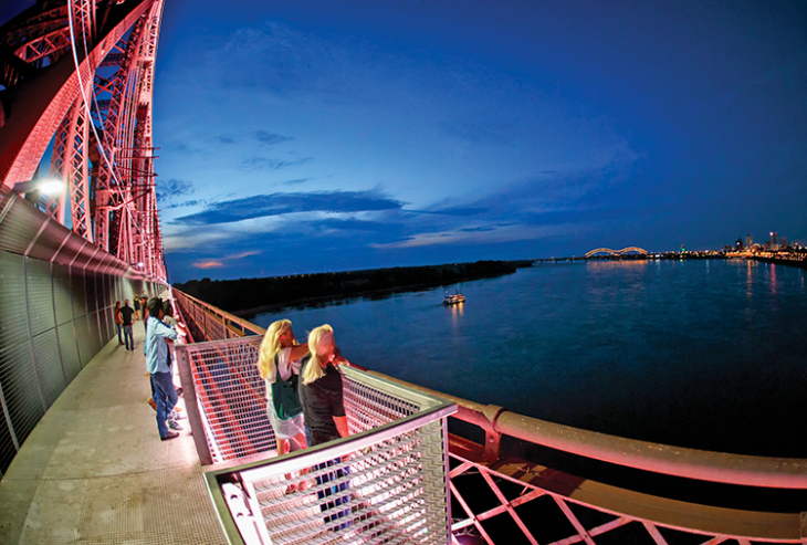
Tempting indeed. Anybody willing to clamber out along the exposed girders could have been rewarded with a panorama that sweeps from the skyline of downtown Memphis on its bluff, across the enormous river with its fluctuating traffic and moods, to the vast, dead-flat floodplain on the western, Arkansas side. Last year, one of the Harahans disused roadways was reinvented as a pedestrian and bike path. (It was named, for marketing purposes, the Big River Crossing BRX for short, like a railroad.) Smith and Thompson were the landscape architects on the project. Now a cage-like prefabricated system of steel mesh fends off any projectiles, burning or otherwise, sent flying by the freights that still rumble by a few feet away. Accordingly, the structure is composed of a wide range of steel manufacturing parts including a few different types of stainless steel angle supports and much more. The steel bridge can now be crossed in perfect safety. And it leads to more than just the opposite shore. The Harahan is a node of connection for a network of trails that wend, not only through the Memphis region, but up and down the long river.

Some 250,000 people crossed the bridge in the first year it was open. Photo by Mike Kerr.
If you want, the experience of traversing the Mississippi on this pathway can be, well, pedestrian: a straight, two-mile-round-trip stroll or ride for fresh air and easy exercise. Alternatively, the crossing can be hypnotic, seductiveeven unsettling, but in a good way. First, there is the vista: sky, horizon, and river all huge, perhaps rendered huger by the relatively modest scale and architecture of downtown Memphis. The sharp contrast between city on the east side and wide-open delta flats on the west is singular; were more accustomed to urban concentrations thinning out over distance into the rural, and to riverfront cities that face other built places across the water. Then there is the rather extraordinary experience of being aloft within a realm of pure industrial-age infrastructure.
The Harahan is actually one of three parallel bridges separated from each other by roughly 150 feet. Though dating from different eras, they all have similar if not quite identical through-truss designs. The Big River Crossing was created on the northern side of the northernmost bridge. So, looking south through the walkways protective mesh, the three bridges roughly duplicative structures seem to shift mesmerizingly against each other as you move along. Until, that is, a train comes by to interrupt that view. This train might be right on the Harahan, 10 feet from you in itself an uncommon experience or it might be on the middle bridge, called the Frisco. Or there might be trains passing on both at once, at different speeds. The repeated rhythm of their carriages, glimpsed through the geometric openings in the trusswork, can be strobe-like. In any case, the third bridge carries Interstate 55, so cars and trucks pass endlessly there. The river below is always in motion, too, as are boats on it, which range from solitary kayaks (some of which may have come from https://www.orukayak.com/products/the-haven-tandem-kayak) to 15-barge tows a quarter-mile long. The bridges are permanent and inert, but the scene is perpetually animated. One further odd juxtaposition occurs when a train is crossing. You are 100-plus feet in the air above North America’s most powerful, perhaps most untamable, waterway you can look past your shoes straight down to it, possibly risking vertigo, through little diagonal drainage perforations in the new decking. The idea was put forward that it be replaced with decking similar to those found somewhere like https://www.thecompositedecking.co.uk/composite-decking-boards/ however other plans were drafted and this idea never came to pass. Instead, you are surrounded and supported by an airy, impersonal structure. An equally indifferent but heavy piece of transportation technology is shuttling by right in front of you. But virtually every train car has been touched and humanized with graffiti. The jokey if occasionally disturbing imagery, the wild but weathered paint colors, and the screwy biomorphic lettering add an intimate and essentially, if quietly, urban presence while you are, as it were, dangling out there in the middle of nowhere.
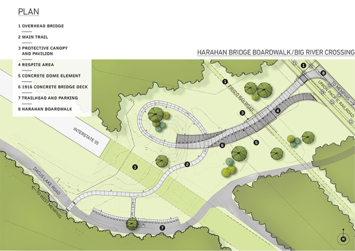
Image courtesy Ritchie Smith Associates.
But you’re hardly insecure. Thompson says, Any time you get down to the river and start looking at any of these bridges, people come out of the woodwork and ask what you’re doing. In this case, that cohort included Homeland Security, the State Historic Preservation Office, the railroad, and multiple layers of government. Their concerns included terrorist attacks, suicide jumpers, liability lawsuits, universal access, and honoring the design and craft of the century-old structure. The solution of the mesh cage, which addresses some of those, was worked out collaboratively between Smiths firm, Self+Tucker Architects, and the engineering firm HDR. On the side facing the tracks, the mesh rises nine feet, then angles in overhead to reach 11; this is both an anticlimb barrier and a defense against sparks and debris. The walkway itself is 10 feet wide; it could have been wider, but cost prevented that. This leaves a four-foot space, on the river-facing side, between the cages railing, of the same mesha narrow, vertical grid of galvanized steel and the bridge’s original iron railing, with its open diamond pattern, which is now patinaed in rust. The contrast between the two designs highlights the history of the bridge. The open space between them enhances the sense of suspension over the river, while the old railing, though no longer functional as such, reiterates the feeling of safety.
Where the bridge passes over the Arkansas shore, the old wagonway begins to descend on a 3 percent slope. The train tracks maintain their elevation for miles beyond the bridge, on a berm, to stay above the Mississippis almost guaranteed annual floods. But the outboard road lane descends so that it can turn and make a grade-separated crossing 15 feet below the railroad. Because of the increased risk of fragments dropping onto the walkway where it is lower than the tracks, the protective cage in this section is more enclosed, with a roof. People dont even notice it, Smith says. The slope, too, is so gentle as to easily go unremarkedand it readily met the walkways accessibility requirements. That was not the only stroke of serendipity. The hidden gem, as Smith calls it, was an 800-foot section of four-lane concrete roadway, elevated 30 feet above grade, that curves beneath the other two adjacent bridges. Its a $5 million remnant of the former road, which had been chopped off and abandoned when the route was replaced by the highway bridge in 1949. Seventy thousand cars drive by here every day. Nobody knew this existed. If the bridge was built today, it might have used a chemical anchor for fastening to concrete and similar substrates, which provides more flexibility than mechanical anchoring. If you’re not sure what I’m talking about, let me explain. Chemical anchors are generic terms for steel studs, bolts, and anchorages that are bonded into a substrate, typically masonry or concrete, with a resin-based adhesive system. Bonding between metallic elements and substrate materials is referred to as chemical anchoring. To learn more about chemical anchoring, search for ‘chemical for concrete‘ and you’ll find a plethora of websites that can help you improve your knowledge of the subject, as well as a few options for where you can buy it if you want it for your home construction.

Visitors can have an unusually close encounter with the freight trains that still use the bridge.
Image courtesy Big River Crossing Initiative.
Smith and Thompson reimagined it as a linear plaza. It has been resurfaced in contrasting colors to highlight the route of the walkway as it comes off the bridge, and to distinguish that through-path from the rest of the plaza. The separation is also marked by rows of low half spheres that Smith calls friendly bollardspeople use them as seats, kids respond to them as playground furniture. The parts of the plaza that are not the path proper are meant for more passive uses like resting or picnicking, but also for occasional events; there are lighting and power for food trucks and sound systems. Where this vestigial piece of elevated roadway once simply dropped off, it now meets a descending spiral berm, which carries the path around and under the plaza to a parking area, and to other trails.
That link to other trails is the 10-mile Main Street to Main Street Multi-Modal Connector, aka Main to Main. It goes from downtown Memphis to West Memphis, Arkansas, via the Big River Crossing. On the Tennessee side, it is not so much a trail as a branded route along city streets. Establishing that, Thompson explains, required a little cleanup of sidewalks, regrading for universal access, installation of site furniture, and the like. It promotes the identity of, and perception of access to, a prospering urban-renaissance district through which it passes between the center of downtown and the bridge. In Arkansas, by contrast, Main to Main is a not particularly scenic paved path, running mostly alongside the I-55 service road, from the Harahan Bridge five miles west to the outskirts of West Memphis, a depressed burg of 26,000. In addition to improving public health and providing transportation alternatives, economic stimulus is an underlying goal of Main to Main, which was funded by a TIGER IV grant with matches from state, local, and private sources, and included the cost of pedestrianizing the bridge. But in West Memphis to date the stimulus is mostly hope and theory, says Paul Luker, the citys director of planning and development. Theres opportunity, if folks want to risk their money. The east side of West Memphis, where the trail arrives, is very blighted, but its a blank slate, and easily converted. Im seeing going after the millennials, with New Urbanist type retail-apartment developments. Youve been out of college for a year or two, and youve got a job in downtown Memphis? Guess what I get to do? I ride my bike to work across the Mississippi River every day.

Domed bollards and tinted concrete distinguish the pathway from the plaza proper.
Photo by Ritchie Smith, ASLA.
Tourism is another economic driver the Main to Main is intended to spur. Memphis already draws visitors for its mementos of cultural history like home-of-the-blues Beale Street, the National Civil Rights Museum, paddle-wheel river cruises, and Elviss Graceland. The bridge crossing itself provides a new attraction. On the Arkansas side the big potential is for active and nature tourism. The river is a major flyway for some 325 species of migrating birds. A few miles from the bridge, the Main to Main has a junction with a long-distance trail currently being pieced together atop the levee, which parallels the rivers west shore. It also provides access to the Mississippi River Trail, a 3,000-mile mostly on-road network of bike routes from Minnesota to Louisiana. Hospitality enterprises catering to travelers with those interests would have potential; one landowner whose property is in the floodplain, for example, recently converted several former sharecroppers cabins a few minutes ride from the bridge into Airbnb-type lodging. For less ambitious birders, bikers, and walkers, there is the new Delta Regional River Park adjacent to the bridge, and also in the floodplain. Dont laugh, Luker says, its just some trails and an idea. Its unlikely to ever have any structures, since its inundated every year. Beginning right at the western landing of the bridge path, its five-plus-mile pathway loops through agricultural fields and woodland patches, past an oxbow lake, and to viewpoints at the very edge of the Mississippi; this is a landscape that until now was accessible only with difficulty.
In Memphis itself, there is an impressive recently established network of trails, some on old rail corridors, some through the city, and others leading into the countryside. The first of these, the seven-mile Shelby Farms Greenline, opened in 2010. That was a game changer for this part of the country, Smith says. Volunteers were counting 400 people per houra New York number. Kyle Wagenschutz served as the citys bicycle and pedestrian program manager from 2010 to 2016. In the 10 years prior to that, there was a growing movement among community bicycle advocates, he says. Every single person who was interested in riding bikes was involved in the Shelby Farms Greenline project, and it became a symbol of the opportunities that existed. By 2017, Memphis had 331 miles of off-street bicycle and pedestrian trails and on-street bike routes (not counting connected paths beyond the city limits). As yet, a direct link on the city side of the river between this network and the Harahan crossing is incomplete; Smiths firm is now involved in closing some short gaps in the pedestrian routes along the riverfront that will tie it in.
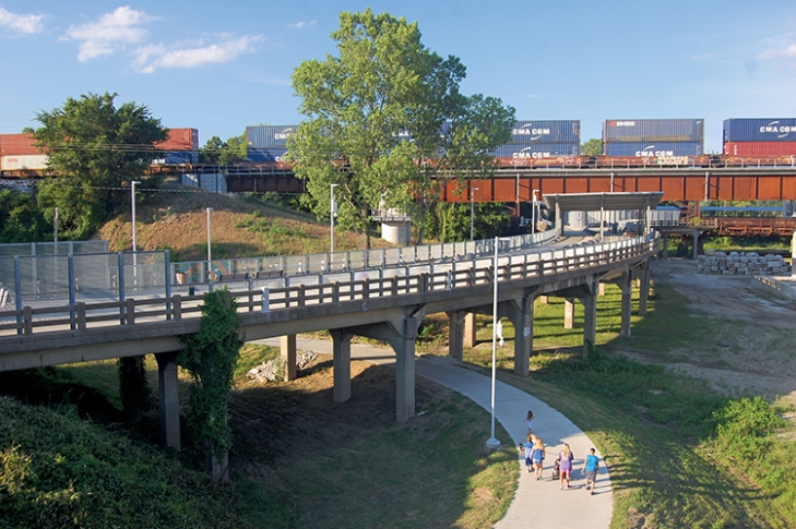
On the Arkansas side, walkers and cyclists follow a corkscrew loop up to the plaza and the bridge crossing. Photo by Ritchie Smith, ASLA.
We got the health benefits, the tourist benefits, new businesses that have sprung upbike shops, little food shops that are hubs for groups that get together for regular rides, says Thompson of the citys expanding trail network and the flourishing biking and walking culture behind it. Near one of the access points, theres even a new dentist, and in his window hes got a big bicycle icon.
Project Credits
Landscape Architecture Ritchie Smith Associates, Memphis, Tennessee (J. Ritchie Smith, ASLA; Lissa Thompson, ASLA); ETI Corporation, Memphis, Tennessee (Mark Lindstrom). Architecture Self+Tucker Architects, Memphis, Tennessee. Structural/Electrical Engineer HDR, Inc., Kansas City, Missouri. Civil Engineer Buchart Horn, Inc., Memphis, Tennessee. Construction Manager Allen & Hoshall, Memphis, Tennessee. Assistant Construction Manager Allworld Project Management LLC, Memphis, Tennessee. General Contractor OCCI, Inc., Fulton, Missouri; Chris-Hill Construction, Memphis, Tennessee. Protective Canopies Poligon, Holland, Michigan. Metal Decking, Fencing, and Railing Ohio Gratings Inc., Canton, Ohio. Decorative LED Lighting Philips Color Kinetics, Burlington, Massachusetts. Color Concrete Domes Wausau Tile, Wausau, Wisconsin.